
Datum: 22. januar 2025.
Lokacija: Riverina, Novi Južni Wales, Australija
U srcu Riverine, jedne od najvažnijih poljoprivrednih regija Australije, poljoprivrednici su osjećali sve veći pritisak klimatskih promjena. Nekada pouzdani obrasci padavina postali su nepravilni, što je uticalo na usjeve i stoku. Kako je nestašica vode postala gorući problem, inovativna rješenja bila su neophodna kako bi se osigurao opstanak i održivost njihovih poljoprivrednih praksi.
Izazov upravljanja vodama
Jack Thompson, uzgajivač pšenice i stoke u četvrtoj generaciji, proveo je bezbroj sati proučavajući vremenske obrasce i sisteme za navodnjavanje. Suše prethodnih godina uzele su danak na njegovoj farmi, a ožiljci očaja bili su očigledni. Mnogi lokalni poljoprivrednici kolektivno su odahnuli od frustracije dok su se neprestano borili da održe produktivnost usred neumoljivih toplotnih talasa i smanjenja zaliha vode.
„Bilo je teško“, priznao je Jack jedne večeri svojoj ženi,Lusi, dok su pregledavali svoje finansije. „Potreban nam je bolji način za praćenje vodostaja i brzina tokova, posebno s obzirom na to da se nivo rijeka tako nepredvidivo mijenja.“
Novo doba tehnologije
Proboj se dogodio kada je lokalna poljoprivredna zadruga najavila dolazak najsavremenijeg hidrografskog radara tri u jednom, dizajniranog posebno za poljoprivrednike. Ova inovativna tehnologija nije samo mjerila nivo vode; također je procjenjivala brzinu vode i potencijal poplava, postajući ključni alat za efikasno upravljanje vodnim resursima.
Nakon što je svjedočio prezentaciji o njegovim funkcionalnostima, koje su uključivale prijenos podataka u stvarnom vremenu i intuitivnu aplikaciju koja je omogućavala poljoprivrednicima da prate uvjete putem svojih pametnih telefona, Jack je odlučio investirati. „Ovo bi nam moglo sve promijeniti“, rekao je Lucy, a njegovo uzbuđenje bilo je opipljivo.
Instalacija
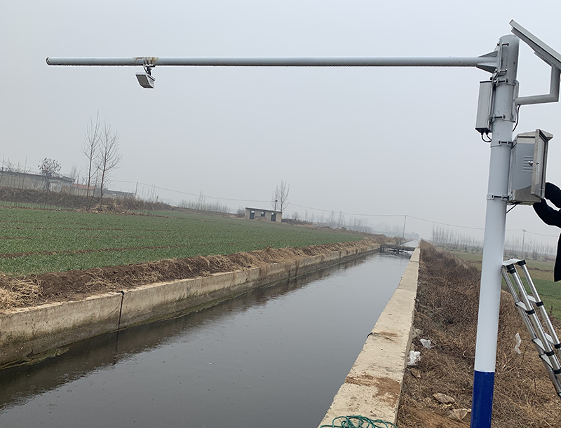
Sedmicu kasnije, tehničar iz zadruge stigao je da instalira hidrografski radar u blizini obala rijeke Murrumbidgee, koja je tekla pored Jackovog imanja. Uređaj je bio elegantan i moderan, opremljen senzorima koji su fotografisali nivo vode, bilježili brzine protoka i upozoravali farmere o potencijalnim poplavama.
Dok je tehničar završavao postavljanje, objasnio je: „Ovaj radar će vam dati uvid u stanje rijeke u stvarnom vremenu. Možete prilagoditi navodnjavanje u skladu s tim i biti u korak s prijetnjama poplavama.“
Jack je osjetio nalet nade. „Ovo znači pametnije upravljanje vodom“, pomislio je. „Radi se o proaktivnom, a ne reaktivnom pristupu.“
Prednosti podataka u realnom vremenu
U narednim sedmicama, Jack je postao vješt u korištenju radarske aplikacije. Uz ažuriranja o nivou vode i brzini protoka u stvarnom vremenu, mogao je efikasno upravljati svojim sistemom za navodnjavanje, osiguravajući da njegovi usjevi dobiju upravo pravu količinu vode bez prekomjernog trošenja resursa.
Jednog dana, kada ga je aplikacija upozorila na porast vodostaja zbog neočekivanih padavina uzvodno, Jack je brzo prilagodio svoj raspored navodnjavanja. „Lucy, moramo za sada odgoditi zalijevanje pašnjaka. Rijeka raste, a ne želimo trošiti dragocjenu vodu“, pozvao je.
Ovim uvidom uspio je uštedjeti značajnu količinu vode, a da ne spominjemo zdravlje usjeva koji bi inače patili od prekomjernog navodnjavanja.
Spašavanje zajednice
Pravi utjecaj hidrografskog radara osjetio se tokom oluje koja je nekoliko mjeseci kasnije zahvatila Riverinu. Obilne kiše poplavile su mnoge lokalne rijeke, ali Jackova predviđanja, potpomognuta upozorenjima radara, omogućila su mu da pripremi svoju farmu. Ojačao je vodene barijere i preusmjerio dio svoje infrastrukture za navodnjavanje, štiteći svoja polja od potencijalnih poplava.
„To je bilo tijesno“, rekao je Jack Lucy dok su pregledavali polja nakon što je oluja prošla. „Uspjeli smo spriječiti bilo kakvu štetu zahvaljujući radaru.“
Priče o Jackovom uspješnom planu upravljanja vodama ubrzo su se proširile poljoprivrednom zajednicom. Drugi su počeli primjećivati i tražili obuku za novu tehnologiju. Zajedno su formirali zadrugu koja je dijelila podatke i strategije, njegujući osjećaj zajedničke otpornosti.
Vizija za budućnost
Godinu dana kasnije, lokalna poljoprivredna zadruga organizovala je konferenciju na kojoj se raspravljalo o budućnosti poljoprivrede u Riverini. Jack, koji se sada smatra pionirom, strastveno je govorio o uticaju hidrografskog radara tri u jednom na njegovu farmu i zajednicu u cjelini.
„Usvajanje tehnologije nije samo ušteda vode; radi se o osiguranju naše budućnosti“, podijelio je s okupljenim željnim poljoprivrednicima. „S podacima u stvarnom vremenu možemo ublažiti rizike od poplava i suša. Ovdje se radi o prilagođavanju našoj promjenjivoj klimi, uz istovremeno promoviranje održivih praksi.“
Dok je prolomio aplauz, Jack je pogledao Lucy, koja je sijala od ponosa. Poljoprivredna zajednica bila je ujedinjena, naoružana inovativnim alatom koji im je ne samo pomogao da se nose s pritiscima klimatskih promjena, već im je i pružio nadu.
Zaključak
U godinama koje su uslijedile, kako su suše i poplave nastavile predstavljati izazov za australijske poljoprivrednike, primjena naprednih tehnologija poput hidrografskog radara tri u jednom postala je vitalni dio poljoprivredne otpornosti. Farma Jacka i Lucy je napredovala, ali što je još važnije, bili su dio šireg pokreta koji je transformirao način na koji su se poljoprivrednici širom Riverine suočavali s izazovima vezanim za vodu.
Kroz inovacije, saradnju i prilagođavanje, oni nisu samo preživljavali; oni su utirali put održivoj budućnosti, osiguravajući da će australijsko poljoprivredno naslijeđe opstati, bez obzira na vrijeme.
Za više informacija o senzorima za vodeni radar,
Molimo kontaktirajte Honde Technology Co., LTD.
Email: info@hondetech.com
Web stranica kompanije: www.hondetechco.com
Vrijeme objave: 22. januar 2025.